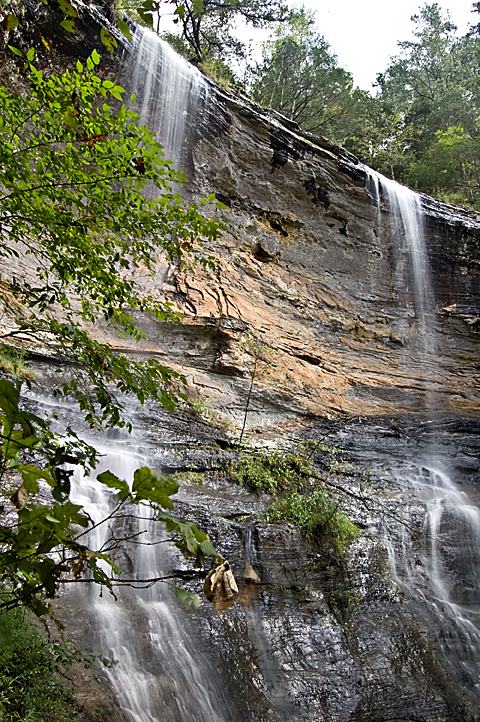
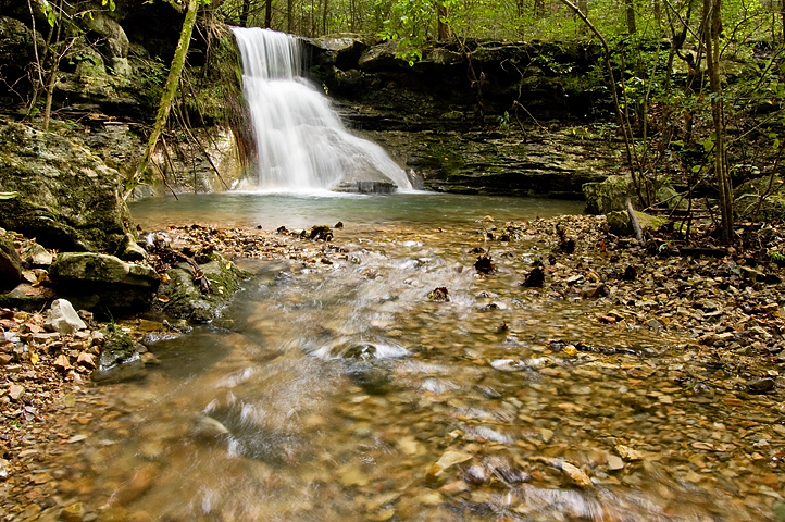
Sometimes I’m a stupid, stupid man. When I got up at 5:30 Saturday morning to head up to King’s Bluff Falls north of Russellville, I had it in my head that the temperature was going to be in the 40s and the sun would be out part of the time. (In my defense, I got that from the weather forecast.) I donned my thin silk long underwear and put on my old New Balance running shoes over a pair of heavy wool socks. I also took two fleece jackets and thought I might be overdoing it in the warm clothes department. I was startled to find snow still on the ground when I turned north from Russellville on Highway 7. And when I got to the parking lot at the trail head, it was flat cold and the wind was whipping over the mountaintop. No sun was showing and wouldn’t the whole day. A good day for waterfall shooting, but bad for staying warm. The nice thing about the overcast and the wet ground is that the colors really saturate in the photos.
My Dad and I made our second-annual day-before-the-end-of-daylight-savings-time-sunrise pilgrimage on Saturday. The first annual DBTEODSTP was so successful, we decided to do it again. This year we went to Petit Jean State Park and caught the sunrise from Stout’s Point near the gravesite of Petit Jean herself. Several photographers had already assembled by the time we got there. The sunrise wasn’t all that great photographically, but it was pretty neat to hang out up there with my Dad.
If I never accomplish anything else in life I can always say that I was the first person at Cedar Falls in Petit Jean State Park on October 10, 2009. It rained heavily across the Ozarks and Central Arkansas on Thursday night and Friday, so I knew the waterfalls would be running for a few days. The trouble was that Saturday was supposed to dawn with clear skies, and bright sun is no good for waterfall pictures. You need the muted light of cloudy skies to get good photos. I figured if I got out there before the sun got very high, I could do some shooting before things got too bright. Problem number two was that I’d have to go somewhere close by if I was going to be there at sunrise. The only real waterfall close enough for me to get to that early is Cedar Falls. I got up at 5:30 a.m. and got to the trail head a little after 7. And as luck would have it, it stayed cloudy, dark and gloomy all day. The top photo is a panorama made from six blended and merged photos.
… like an old man trying to send back soup in a deli.
I had been to Longpool Falls in Pope County north of Russellville back in January, but I didn’t get any photos worth looking at. So when a huge deluge hit that part of the state on Friday I decided to go back and see it when it had something to show. When I got up at 7:30 a.m. Saturday the rain had made it to Little Rock, but it was still raining in Pope County. I drove through torrential rain all the way there and the rain the didn’t stop. The top photo is a two-frame panorama of Longpool Falls and the ravine downstream.

Copperhead Falls seen from the top.
This past weekend found me making yet another journey to our summer home in Northwest Arkansas to deal with the aftermath of the Epic Ice Storm of 2009. Thankfully, I didn’t have to do any manual labor this time. I just paid a man I hired over the over phone to climb up in our once magnificent shade trees and cut down the hanging limbs. I realize hiring people over the phone to perform work the results of which you won’t see for a week is fraught with hazard but it worked out well this time.
On my way back to Little Rock, I detoured over to the Buffalo River to hike Indian Creek and see Copperhead Falls and Tunnel Cave Falls. The hike is billed as a dangerous one, but I found it less hazardous than the hike to the slot canyon on Shop Creek I took a few weeks ago. Indian Creek is actually the next drainage over from Shop Creek. An ambitious hiker could do both in one day if he started early enough.
The leaden sky was spitting snow, I had hiked a mile or so over snot-slick moss, rocks and logs, my coccyx was sore, and I was ledged out well short of my destination.
Back in the summer I had read in Tim Ernst’s blog about the slot canyon on Shop Creek upstream of the famous Twin Falls in the Buffalo National River area, and I put it in my mental file of places to go. I spent the day Saturday cleaning up ice storm damage at our summer home near Fayetteville and planned to get up early Sunday and do some waterfall hunting before heading back to Little Rock. Ernst hadn’t given the location of the slot canyon on his Web site but a little Internet sleuthing turned up this blog, which described how to get there. Thanks, Derek. It turns out you just go to Twin Falls, which is easy to get to, and then continue upstream. Derek has some good photos of the slot canyon and Tim Ernst has his usual stellar photos of the place. Both Tim and Derek wrote about the difficulty of accessing the canyon. Both of them even recommended rock climbing gear, and, in fact, Ernst wrote about using a harness to hang out over the creek to get his pictures. But I figured I could get in there a little ways at least. I was wrong.
I set out Saturday for the third weekend in a row looking for some fabulous fall foliage. I failed. In the hope that the leaves down south were still in peak form, I headed down to the Cossatot Falls State Park. As I headed down I-540, I could see the leaves in Northwest Arkansas were about done. I was hoping the foliage would get better the farther south I traveled on Highway 71. I was disappointed. Plus, the area I went to might not be the best for fall color anyway. The area is mostly timber company land planted in pine trees. The little swirly parts in the photo become raging whitewater holes when the river comes blasting through after heavy rains. The river is typically low in the fall. On Saturday, you could have easily waded across without a problem. Cossatot is supposedly an Indian word that means skull crusher. They say this is the most challenging whitewater in Arkansas.
Hurricane Ike dumped a bunch of water overnight Saturday so I set out about 9 a.m. to look for some rare September waterfall action. I planned to hit Murray and Senyard Falls off the Pig Trail north of Cass and then maybe check out the cascades below Lake Sequoyah on my way back home.
Hurricane Gustav parked itself over Arkansas most of last week and dumped a whole bunch of rain, so I hoped enough water would be left running on Saturday to have the waterfalls at full glory. Perusing the Arkansas waterfall Bible written by Tim Ernst, I picked out Tea Kettle Falls to visit.
Tea Kettle is in the Madison County Wildlife Management Area south of Eureka Springs about a mile off a gravel road. It’s a pretty good hike, about a mile down Warm Fork Creek with no official trail. You just follow the creek through the woods. The picture above is a waterfall on a side creek visible from the main creek. The Warm Fork probably only runs during wet weather. Despite there being plenty of water in it, I didn’t see a single fish or other water creature. And the water was clear as gin. Creeks and rivers in the Ozarks normally have an emerald green tint from mineralization, but this water was as clear as any I’ve ever seen.
I’ve always loved waterfalls and with all the water that’s fallen from the sky this spring, the water falling from the rocks has been spectacular. I tried taking photos of them in the past with film, but I just didn’t do it enough to become proficient. The lag time between shooting and developing film and seeing mistakes and remembering them and correcting them the next time out was too arduous for me. I’d rather just go play golf with its instant feedback. But with a digital camera I can shoot, check out the LCD, spin some dials, push some buttons and try again until I get something I like.
Now, I’m not disappointed with the exposure, but a lot of times I’m disappointed with the composition. I did like the composition on this shot of the underside of the Glory Hole near Fallsville in the Ozark National Forest.
I’ve gone kind of goofy on photographing the waterfalls. I bought the Tim Ernst waterfall guidebook and I’ve been mapping out what falls I want to see before they dry up this year. Gina, Abby and I went out Saturday looking for King’s River Falls and it was a total bust. It was sunny and we were out too early in the day. Abby got grouchy after 3 hours of riding around, which meant Gina was grouchy and I was grouchy. After all that we didn’t even get to see King’s River Falls because the road was too washed out for Gina’s Honda Accord to navigate.


