Landscape

The Fog

_D6H5169blogsmall

On Saturday we took off on one of our daylong drives and found ourselves high in the Ozarks in Pope County. Once we hit a certain elevation – about 1,800 feet – we were inside the clouds. Thick, wet clouds. The fog was thick that I got pretty freaked out driving on serpentine Highway 7. You couldn’t see the oncoming vehicles until they were about 60 feet away. I just kept imagining a big-ass truck appearing out of the fog across the centerline in my lane.

_D6H5177blogsmall

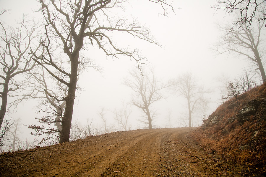
We crossed over Pilot Mountain on our way home and I stopped a few times to get some snaps of the fog.

Can’t Beat A Rainy Day For A Good Hike

dsc_9342blog

When I woke up at 7:30 a.m. Sunday, the sky was clearing after a night of off and on rain and I was so bummed I almost just went back to sleep. I hadn’t gone to sleep until around 4 a.m., which made actually getting up that much harder. (I think I’ve developed insomnia.) Sunny skies spell poor conditions for shooting waterfalls. You need the even, reduced light of overcast skies to make that silky water effect.

But, as we will see, Lady Fortune is a fickle traveling companion.

Another Wasted Saturday

dsc_2501blog

I set out Saturday for the third weekend in a row looking for some fabulous fall foliage. I failed. In the hope that the leaves down south were still in peak form, I headed down to the Cossatot Falls State Park. As I headed down I-540, I could see the leaves in Northwest Arkansas were about done. I was hoping the foliage would get better the farther south I traveled on Highway 71. I was disappointed. Plus, the area I went to might not be the best for fall color anyway. The area is mostly timber company land planted in pine trees. The little swirly parts in the photo become raging whitewater holes when the river comes blasting through after heavy rains. The river is typically low in the fall. On Saturday, you could have easily waded across without a problem. Cossatot is supposedly an Indian word that means skull crusher. They say this is the most challenging whitewater in Arkansas.

Fallen Fall

dsc_2349blog

We had planned to go for a drive in the Buffalo River area Sunday to see the leaves, but Abby got sick and Gina felt a 103 degree fever was not conducive to viewing fall foliage. Gina cut me loose for the afternoon and I headed out by myself.

I drove to Ponca and bought a map of the hiking trails in the western part of the national river park. Parking at the Ponca access to the river, I took off east on the Old River Road Trail, which I had never been on before. The scenery in he Buffalo River bottom is always nice, but the fall foliage seemed to be past peak down there. I bet the trees along the river in the top photo were afire in red and yellow a week ago. That would have made a better picture, of course.

Kings River Sunrise

A couple months ago when I went to check out Eagles Nest Falls in the Madison County Wildlife Management Area I found this magnificent view of the Kings River valley. I made a mental note to try to get back there to see the fall foliage at sunrise. I figured this Saturday would be perfect because the switch back to standard time on Sunday would make sunrise come earlier and make it less likely I would be able to get there early enough. (I realize that sunrise happens when it happens and we humans are the ones who put a time to it. But these are mental gymnastics I used to convince myself that rising at 5 a.m. was a good idea.) My dad was in town and he’s always up way too early and he enjoys a good hike, so he was game to go along with my idea.

Hay, Look At Those Stars

Since I was at my parents’ house in the middle of nowhere Kansas this weekend, I thought it prudent to try a star trails shot with the new camera. Star trails by themselves are pretty cool, but it’s the foreground that usually makes such shots really cool. The best thing I could find nearby were some hay bales.

Though I was really pretty far out in the country, the house has a big street light in the yard and there’s a church about 300 yards from the house with its own big street light. In addition, the small town of Parsons is about five miles away. It was actually hard to find a suitably dark piece of sky without a big street light in the way. Straight up was nice with a ton of stars, but I couldn’t get anything in the foreground with the camera pointed straight up.

What I ended up with was the hay bales with the lights of town behind them and the big light from the church shining on their fronts. That’s why they are that green color. I guess the light was florescent or sodium vapor or something. I shot on daylight white balance in raw and I tweaked it a little in CS3. Exposure was f/10 for about 30 minutes.

Saturday Ramble

Hurricane Gustav parked itself over Arkansas most of last week and dumped a whole bunch of rain, so I hoped enough water would be left running on Saturday to have the waterfalls at full glory. Perusing the Arkansas waterfall Bible written by Tim Ernst, I picked out Tea Kettle Falls to visit.

Tea Kettle is in the Madison County Wildlife Management Area south of Eureka Springs about a mile off a gravel road. It’s a pretty good hike, about a mile down Warm Fork Creek with no official trail. You just follow the creek through the woods. The picture above is a waterfall on a side creek visible from the main creek. The Warm Fork probably only runs during wet weather. Despite there being plenty of water in it, I didn’t see a single fish or other water creature. And the water was clear as gin. Creeks and rivers in the Ozarks normally have an emerald green tint from mineralization, but this water was as clear as any I’ve ever seen.

Ahhhhrrrggg

Pikes Peak shot from the dam at Manitou Lake, which is about 7 miles north of Woodland Park, Colo. My photos here turned out pretty noisy because I failed to turn off the auto ISO feature when I switched to manual exposure mode. The camera bumped the ISO to 1600 and I didn’t know it until a couple weeks later. I was pretty bummed because I loved the light and the reflection on the lake. I mean, how many times am I gonna be able to shoot Pikes Peak in such cool light? Lesson learned, I guess.

Hawksbill Crag

Dad and I drove down to the Buffalo National River and hiked to Whitaker Point and visited Hawksbill Crag, perhaps the most photographed natural feature in Arkansas. On the drive down we encountered a huge thunderstorm, part of a swarm of storms in Oklahoma, Missouri and Arkansas that killed a bunch of people. We pulled off under a tree when the hail got too bad. As we started off down the trail, we heard the ominous sound of thunder. We planned to visit Upper Haley’s Falls and then go on to Hawksbill Crag. Tim Ernst named the falls in his waterfall guidebook after Haley Zega who got lost in the area in the 2001. I suggested that the waterfall probably had a huge overhang — because most waterfalls in the area do — and we could take refuge under it if need be.